Waterfront can mean different things on Figure Eight Island, and those differences matter when you buy or sell. You might imagine private sand, a dock at your back door, or sunset views over calm marsh. Each version comes with its own rules, costs, and benefits. In this guide, you’ll learn what “waterfront” really means here, how regulations shape your options, and how to protect your investment. Let’s dive in.
Waterfront types on Figure Eight Island
Oceanfront and beachfront
Oceanfront parcels face the Atlantic with an active sandy beach in front of the primary dune line. You enjoy sweeping views and direct proximity to the water. These sites also see higher wave energy, storm surge exposure, and are often mapped in coastal high-velocity flood zones.
Dune-front and deeded beach access
Some homes sit behind protective dunes rather than open beach. You may also see listings that advertise “beach access,” meaning a deeded right-of-way, association easement, or private path to the beach. That is different from true oceanfront ownership down to the mean high-water line.
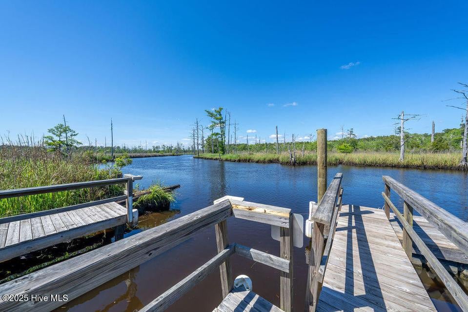
Canal and dockfront interiors
Interior canal or tidal-channel lots offer protected waters and, in many cases, private docks or slips with potential access to the Intracoastal Waterway. Water is calmer and boating is a key lifestyle driver. There can be shared channel upkeep and riparian docking-rights considerations.
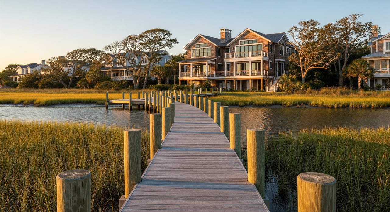
Marshfront and tidal creek edges
Marshfront and creek-facing lots deliver serene views and rich coastal ecology. These areas are tidally influenced and environmentally sensitive. Erosion or accretion can affect the marsh edge, and construction is often more limited.
Water view vs true waterfront
A water view means you can see the water but the parcel does not touch it and typically has no shoreline or docking rights. True waterfront usually means your property abuts navigable water and may include riparian or littoral rights. The precise rights depend on your deed, plat, and permits, so review them carefully.
Public vs private beach lines
In North Carolina, the wet-sand area seaward of the mean high-water line is generally subject to public use under public trust principles. On Figure Eight, many oceanfront owners hold title landward of that line, often including dry sand and dunes. Ownership does not grant exclusive control over the wet sand below mean high water. On a private, gated island, physical access is controlled by the POA, but the legal distinction between wet sand and dry sand remains important when you think about use and privacy.
Permits, setbacks, and rules
State coastal permits and setbacks
North Carolina’s coastal rules, including the CAMA framework, regulate development near the ocean and other coastal waters. Setback lines, ocean-hazard areas, and special permits affect new builds, major repairs, dune work, and shoreline structures. If you plan seawalls, dune stabilization, or beach access stairs, expect a review and permits. After storms, rebuilds can be limited by erosion-rate setbacks and other criteria.
FEMA flood zones and insurance
FEMA flood maps classify much of the island into special flood hazard areas. Oceanfront tracts often fall in VE zones with higher base flood elevations and stricter building standards. Lenders commonly require flood insurance in these zones. Obtain an elevation certificate early and speak with a coastal-savvy insurance agent to understand premiums and wind or hurricane deductibles.
Riparian rights and dock approvals
Owning to the mean high-water line does not automatically allow a large dock or bulkhead. Docks, piers, and shoreline stabilization usually need approvals from state coastal regulators and often the U.S. Army Corps for navigable waters. Neighboring owners, channel width, and environmental impacts can shape what is allowed. Confirm deed language and recorded rights before you assume slip or mooring capacity.
HOA and private-island governance
Figure Eight Island is a private, gated community with POA rules that can govern access, beach crossovers, dune projects, dock standards, parking, and aesthetics. You will review Covenants, Conditions & Restrictions and architectural or shoreline guidelines during due diligence. POA programs may also coordinate beach nourishment or dune maintenance.
Environmental protections and timing
Barrier-island habitats matter. Sea turtle nesting, shorebird seasons, marsh buffers, and dune protections can limit when and how work can occur. Seasonal windows, lighting rules, and mitigation requirements often apply, so build realistic timelines into your plans.
Tradeoffs that shape value
Price drivers by waterfront type
Oceanfront commands a premium for views and beach proximity. That premium comes with higher insurance, stricter construction standards, and more exposure to storms and erosion. Canal and dockfront homes appeal to boaters who want calm water access and can offer strong lifestyle value. Marshfront brings privacy and scenery, with more environmental considerations. Sellers should label the waterfront type clearly so buyers and lenders set accurate expectations.
Construction and maintenance realities
On a barrier island, elevated homes on pilings, breakaway walls below the base flood elevation, and corrosion-resistant materials are common. Docks, bulkheads, and dune walkovers need periodic care. Budget for ongoing inspection and upkeep. For buyers, ask for permits and repair records to understand what you are inheriting.
Long-term risk and resilience
Barrier islands move over time. Ask about historic shoreline change, past erosion events, and nourishment history for the area of the island you are considering. Review any community-level erosion or nourishment projects. For sellers, be ready to disclose known flood or storm history and any enforcement or permitting actions related to coastal hazards.
Access and amenities considerations
On a private island, gate access, guest passes, and parking rules matter to how you live and host. If a property is not oceanfront, confirm whether you have deeded beach access or use of a POA path. For interior waterfront, verify channel depths, maintenance responsibilities, and any limits on boat size.
Due diligence checklist for buyers and sellers
Use this list to confirm the facts behind the waterfront label.
- Title and deed review: Look for riparian or littoral rights, recorded beach or access easements, and any covenants affecting docks or shoreline work.
- Current survey and mean high-water line: Order a survey that shows the house, the mean high-water line, dune location, and setback lines. Verify whether the lot extends to the dune or stops landward.
- Elevation certificate and flood map status: Confirm FEMA zone designation (AE or VE) and base flood elevation. Keep a certified copy of the elevation certificate.
- Flood-insurance history: Request prior claims and premium history. Ask whether the property is categorized as a repetitive-loss property under NFIP.
- HOA/POA documents: Review CC&Rs, bylaws, architectural and shoreline guidelines, short-term rental rules, assessments, and recent minutes on beach or dune projects.
- Permits and repair files: Collect prior CAMA, county, and Corps permits for seawalls, dune work, docks, and any emergency repairs after storms.
- Shoreline change and nourishment records: Check community or county resources for historic shoreline data and scheduled nourishment projects.
- Utilities and wastewater: Confirm sewer connection or on-site wastewater details and any replacement limitations.
- Environmental restrictions: Note protected species zones, seasonal work windows, and any buffer rules that affect timing.
Buyer steps on Figure Eight Island
- Define your waterfront lifestyle: ocean surf, boating access, or marsh privacy. This choice drives your search and budget.
- Get insurance estimates early: speak with a coastal-focused agent and request a preliminary premium range based on zone and structure details.
- Order a survey and elevation certificate: tie down mean high-water line, setbacks, and base flood elevation before you finalize price and plans.
- Review permits and HOA rules: confirm what you can build or rebuild and any limits on docks, crossovers, or exterior changes.
- Engage local pros: a coastal surveyor, real estate attorney, and contractors familiar with barrier-island codes can save time and money.
Seller tips to market correctly
- Describe the waterfront precisely: oceanfront, dune-front, canalfront, marshfront, or water view only. Be clear about deeded access and docking.
- Prepare documents up front: survey with mean high-water line, elevation certificate, insurance history, and copies of permits and repairs.
- Highlight resilience and maintenance: recent piling work, dune stabilization, or dock upgrades can support value.
- Address risk smartly: be transparent about known flood or storm events and explain any mitigation steps.
- Choose the right strategy: premium marketing for luxury buyers works well for iconic oceanfront and deep-water canal homes. For unique or time-sensitive assets, consider alternate sale strategies that match your timeline and goals.
Bringing it all together
On Figure Eight Island, the word “waterfront” covers very different realities. Oceanfront brings unmatched views and direct beach proximity. Canalfront puts boating at your back door. Marshfront offers quiet and ecology-rich scenery. Each comes with its own rules, insurance profile, and long-term considerations. With the right documents, the right specialists, and clear expectations, you can buy or sell with confidence.
If you are weighing options or planning a move, connect with a local team that lives this market every day. For tailored guidance, premium marketing, and access to specialized strategies when needed, reach out to The Chris Luther Real Estate Team.
FAQs
Is the beach on Figure Eight Island open to the public?
- The wet-sand area below the mean high-water line is generally open to public use in North Carolina, while the island’s private gates control physical access and the dry-sand uplands are typically private.
Do oceanfront owners control the sand to the waterline?
- Ownership usually goes to the mean high-water line, not below it, so owners cannot exclude public use of the wet sand seaward of that line.
Can I add a dock or seawall on Figure Eight Island?
- Most shoreline projects need state coastal permits and often U.S. Army Corps approvals, plus POA review; what is allowed depends on site conditions and neighbor and channel constraints.
How do FEMA flood zones affect my costs?
- Homes in special flood hazard areas, especially VE zones, face stricter building rules and commonly require flood insurance; premiums vary by elevation and structure, so get quotes early.
What are the main tradeoffs by waterfront type?
- Oceanfront offers views and beach proximity with higher insurance and exposure, canalfront favors boating with calmer waters, and marshfront offers privacy with more environmental limits.
What documents should I collect before listing or buying?
- Obtain a recent survey with mean high-water line, elevation certificate, flood and insurance history, HOA rules, and copies of all shoreline and dock permits.